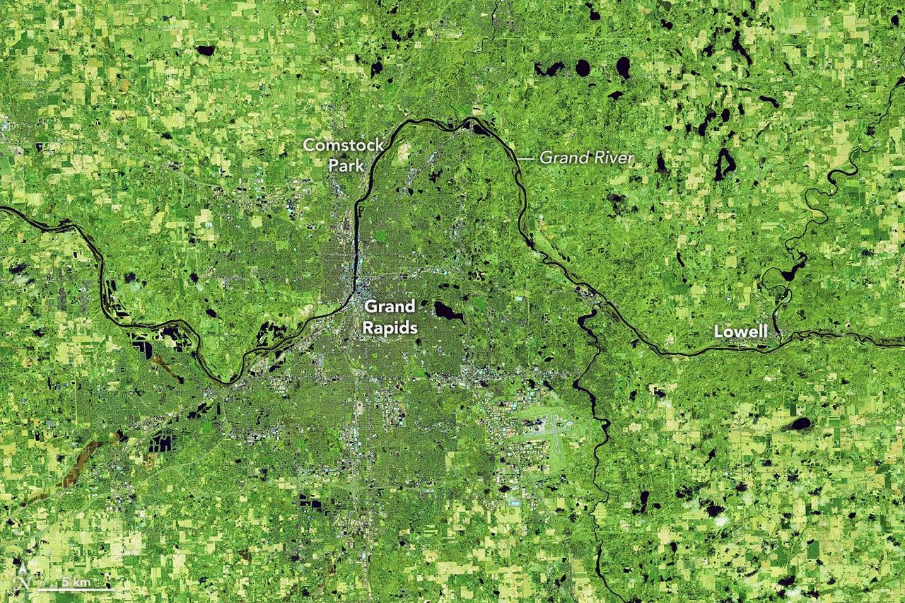
From the vantage of orbit, the shifting boundaries of Earth's water systems reveal the immediate impact of seasonal volatility. Recent satellite imagery from NASA's Earth Observatory highlights a significant expansion of the Grand River in Michigan, which has swollen far beyond its typical spring margins following a period of above-average rainfall. The false-color renderings, designed to distinguish land from water, show the river as a dense, dark-blue ribbon winding across the landscape, with surrounding vegetation rendered in shades of green that underscore the saturation of the region.
Comparing the current data to the same period in previous years, the river has grown notably wider, reclaiming floodplains as it moves from its headwaters in the central Lower Peninsula toward its outlet at Lake Michigan near Grand Haven. The Grand River is the longest river in Michigan, draining a watershed that encompasses a mix of agricultural land, suburban development, and remnant wetlands — a combination that makes it particularly responsive to shifts in precipitation patterns.
A River System Under Pressure
The Grand River basin has long occupied an uneasy position between natural hydrology and human land use. Over the past century, much of the watershed's original wetland cover — which once acted as a sponge during periods of heavy rain — has been converted to farmland or developed for residential and commercial use. The result is a system with diminished capacity to absorb excess water, meaning that above-average rainfall translates more directly into river swelling and floodplain inundation than it might in a less altered landscape.
The city of Grand Rapids, Michigan's second-largest metropolitan area, sits squarely along the river's path. Flood management infrastructure there, including levees and stormwater systems, was designed around historical precipitation norms. When spring rainfall exceeds those norms, the margin of safety narrows. The satellite imagery released by NASA does not depict an unprecedented catastrophe, but it does illustrate a river system operating well outside its baseline — a condition that stresses both built infrastructure and the ecosystems that depend on predictable water levels.
Remote sensing of this kind has become a standard tool in the hydrological monitoring toolkit. Instruments aboard satellites such as Landsat and the joint NASA-USGS platforms capture multispectral data that allows analysts to map water extent with high precision, even when cloud cover or ground-level access would otherwise limit observation. The false-color composites referenced in NASA's release are a product of this approach, rendering water bodies in wavelengths that make their boundaries unambiguous against surrounding terrain.
The Great Lakes Region and Shifting Precipitation
Michigan's experience fits within a broader pattern observed across the Great Lakes basin. The region has seen a documented trend toward more intense precipitation events, particularly in spring and early summer. Heavier downpours separated by longer dry intervals represent a departure from the more evenly distributed rainfall patterns that historically characterized the Upper Midwest. For river systems like the Grand, this means sharper peaks in flow volume — and a greater likelihood that floodplains will be activated in any given year.
The implications extend beyond property damage. Agricultural operations in the watershed face planting delays and soil erosion when fields remain waterlogged. Downstream water quality can deteriorate as runoff carries sediment, fertilizers, and other pollutants into the river and ultimately into Lake Michigan. Municipal water treatment systems must contend with higher turbidity and variable inflow chemistry.
NASA's orbital snapshots, then, serve as more than visual records. They are data points that feed into flood forecasting models, land-use planning decisions, and long-term climate adaptation strategies. The tension at the center of the Grand River's story is a familiar one across much of the developed world: infrastructure and land-use patterns built for one hydrological regime now confronting another. Whether the response takes the form of restored wetlands, upgraded stormwater systems, revised floodplain zoning, or some combination, depends on choices that satellite imagery can inform but not make.
The river, indifferent to those choices, continues to follow the water wherever it leads.
With reporting from NASA Breaking News.
Source · NASA Breaking News